


DroneData
As a key measure, digital imaging from unmanned aerial vehicles, especially drones, and related data analytics were applied.
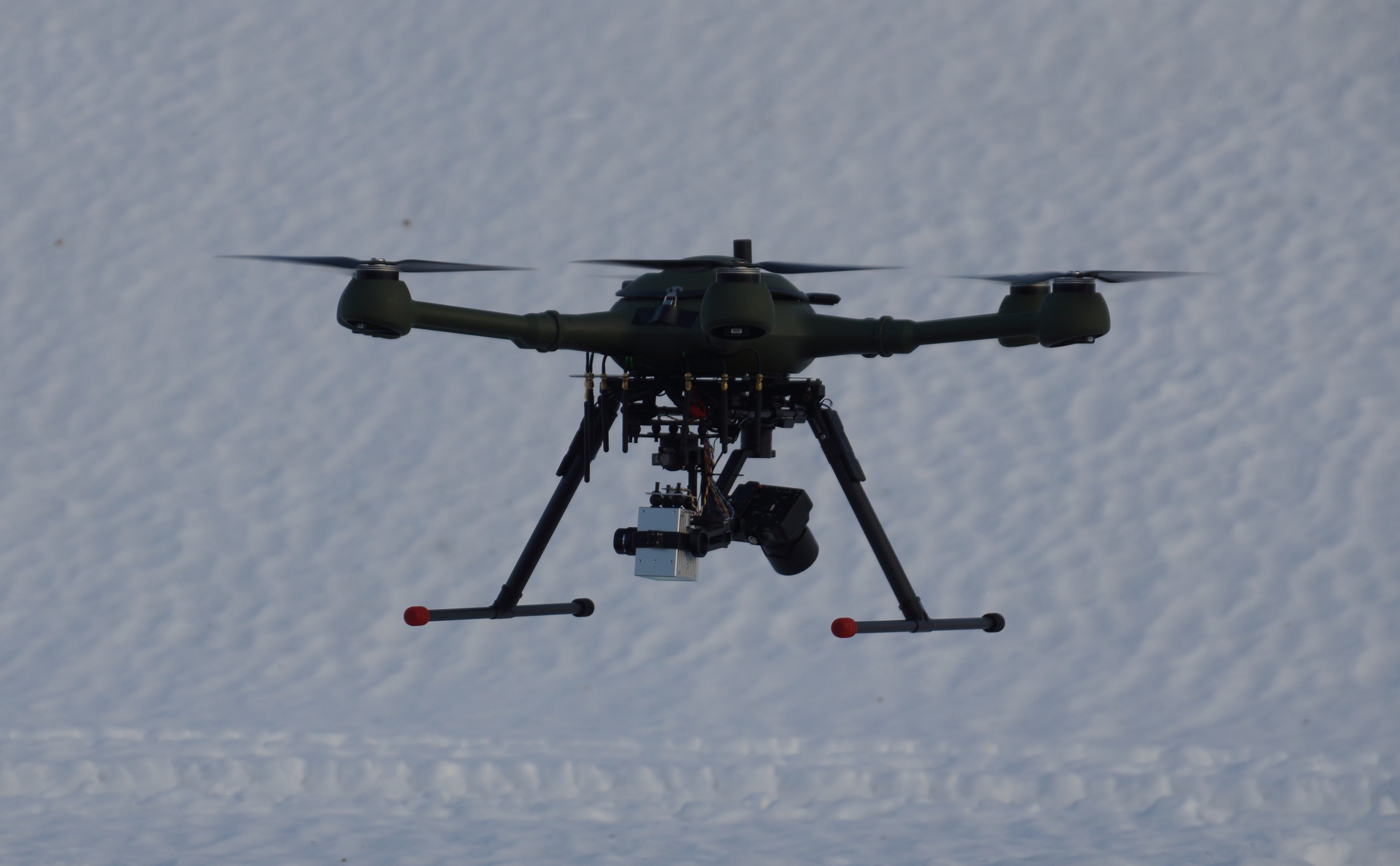
During the project, a prototype-level drone was built, which was tested with various sensors.
Project goals and measures.
The distribution of electricity played a central role in recovery from various natural phenomena caused by climate change and the management of related risks. The project aimed to develop energy companies’ capabilities to respond to different fault situations in electrical networks and to prepare for various natural phenomena-related risks through better maintenance. A central method for achieving this was the utilization of digital imaging from unmanned aerial vehicles, especially drones, and related data analytics. In the project, different drone solutions as well as solutions for imaging and data analytics were tested in various weather conditions and in both fault detection and maintenance.
Promoting adaptation to climate change, risk prevention and disaster preparedness and resilience.
New methods, solutions, and processes were introduced and developed to address these themes based on the needs and processes of energy companies. The project’s objective was to improve readiness for recovering from various natural phenomena and disasters using fast drone-based fault detection with reduced carbon dioxide emissions. The project generated new information that can be used to understand different fault situations and circumstances and to respond to those situations. Additionally, the project developed new methods for handling various situations and circumstances. As a result of the project, knowledge related to the maintenance and risk management of electrical networks was improved.
Measures and work packages
The background of the project
The background of the project involved the critical role of electricity distribution in recovering from various climate-related natural phenomena and managing associated risks. The project aimed to enhance energy companies’ ability to respond to different disruptions in power grids and proactively prepare for risks related to natural events through improved maintenance practices.
Measures and work packages
The key measure was to use digital imaging performed by unmanned aerial vehicles, especially drones, and related data analytics. In the project, different types of drone, imaging, and data analytics solutions were tested for their applicability in fault management and maintenance of power grids in various situations. New methods, solutions, and processes were developed and implemented for these themes, based on all processes and identified needs of energy companies.
Background and needs survey
Background survey
- The various available drone types (including fixed-wing drones) and their suitability as platforms for different sensors were mapped.
- Experiences were collected from the application of technologies related to fault location and management of electrical networks.
Needs survey
- The needs of the participating electricity network companies for the use of drone-based methods in fault management and maintenance, as well as the possibilities of applying drone solutions as part of their operations, were clarified.
- The companies’ current processes and systems in use for fault management of electricity networks were investigated.
Drone experiments
Planning
- The drone experiments were planned and implemented during the project.
Drone experiments
- Drone flights were carried out in various ways in different electrical network environments and conditions, experimenting with different technologies and implementation methods.
- The suitability of various drone platforms for fault location and inspections was investigated.
- The success of drone experiments using different implementation methods was evaluated.
Automation of drone flights
- The necessary mappings for the automation of drone flights were made and a plan for the most cost-effective mobile demo and testing equipment was drawn up.
- Within the available resources and funding, a demo and testing system for automatic drone flights was implemented.
Data analytics
Planning and existing solutions
- The methods and tools to be tested in data analytics were planned based on background mapping and experiences gained from different imaging methods.
- Tools and sufficient knowledge for data analytics in the project’s application area were acquired. If necessary, the development of proprietary data analytics methods was planned from the starting points of the various data collected.
- A solution for data management using cloud services was planned.
Data quality
- Methods for studying the quality and usability of data collected from drones with sensor assistance were developed and implemented.
- The quality of data collected by different sensors under various conditions and at different times of the year was studied.
Implementation and methods of data analytics
- The goal was to find methods that worked in automatic fault location under Finnish conditions.
- Various existing methods and software were extensively tested.
- Methods for analyzing data produced by different sensors from the perspective of fault location and risk management of electrical networks were developed.
Results
As a result of the project, the aim was to be prepared for fast and effective drone-based fault location and repair, suitable for recovering from natural phenomena with lower carbon dioxide emissions than before, as the use of vehicles and helicopters was reduced. The project produced information that helped to better understand various disruptions and situations, as well as methods suitable for different situations and circumstances. As a result of the project, maintenance and risk management skills related to electrical networks were also strengthened.
Public relations and networks
Public relations and publication activities
Information was provided about the project and its results, as well as the possibilities of drone technology in the region. The project results were published both nationally and internationally.
Networking
- The cooperation between the project implementer and the participating companies was intensified and a thematic network of operators was formed around the project’s subject area.
- Networking with other regional operators was established.
- The project results were transferred to the teaching curriculum of the South-Eastern Finland University of Applied Sciences as applicable.
- The materials were used in the training of drone pilots for electrical networks.
Promoting business opportunities
- Opportunities to integrate the results into the business operations of the participating energy companies were identified.
- The opportunities for commercialization of the achieved results were assessed.
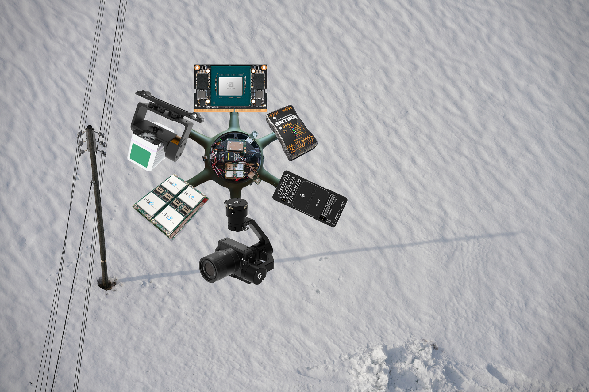
A drone in the making
During the project, a prototype was built and tested at the prototype level. The drone was equipped with the following components:
- Jetson Xaviex NX
- Air Commander Entire r3
- Cube Black
- Sony ILX-LR1 + Gremsy Gimbal
- Elsight Halo
- Livox Avia + CopterLab Gimbal
The project has also used a DJI M300 RTK drone with sensors such as:
- DJI Zenmuse H20T thermal camera
- DJI Zenmuse H30 camera
- DJI Zenmuse P1 camera
- DJI Zenmuse L1 LiDar
- Sony ILX-LR1 with custom gimbal
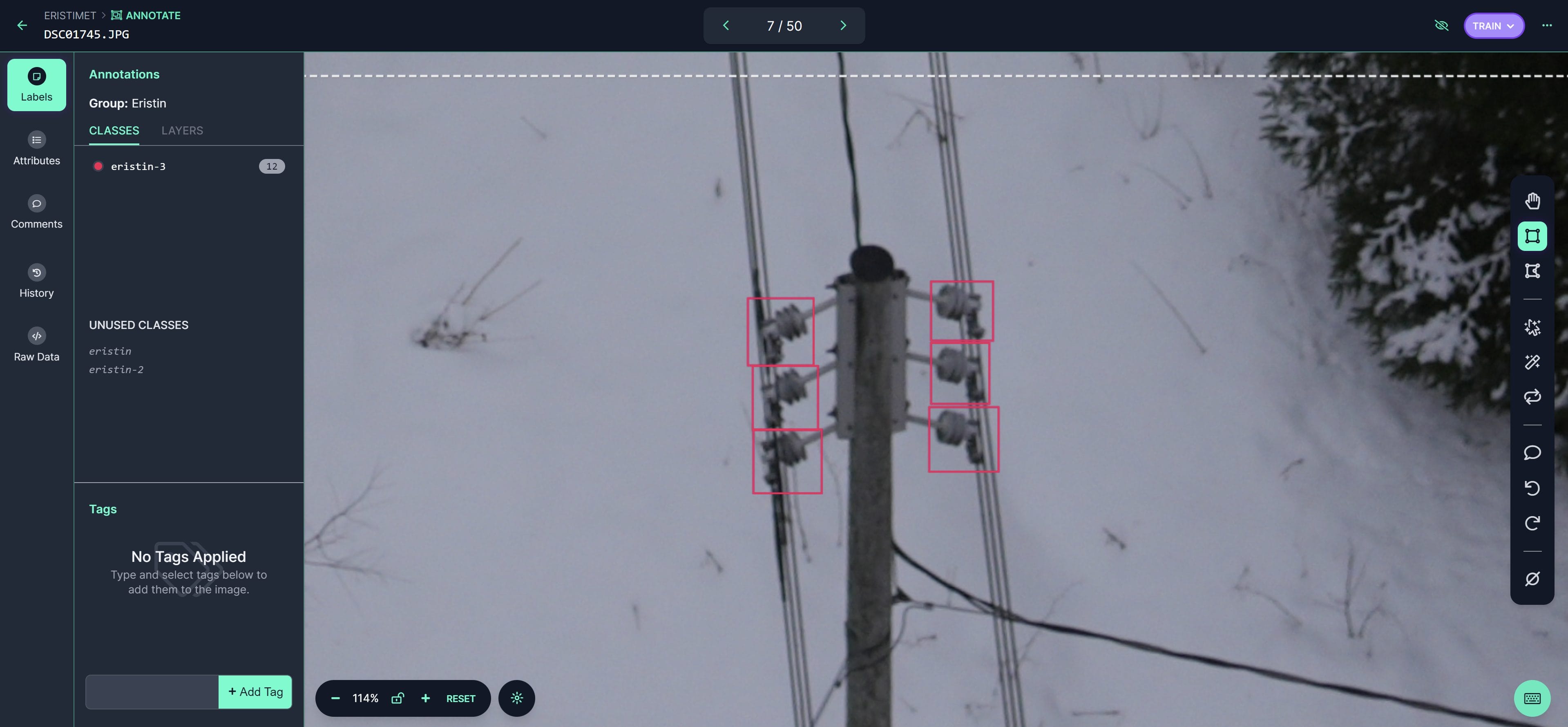
Machine vision model
During the project, power lines were filmed, and data was collected. Based on this data, a machine vision model was developed on Roboflow’s web platform. The machine vision model was made freely available for everyone to download and utilize.
Machine vision model is freely available for everyone to download and utilize.
Facts
Drones and Data Analytics in the Fault Detection and Maintenance of Electric Networks – DroneData
Info
Budget
Project partners